Tony Barboza | LA Times | Link to article
An environmental group has identified nearly 250 locations where planet-warming methane is leaking from natural gas lines under streets in the Greater Los Angeles region.
Environmental Defense Fund researchers outfitted a Google Street View mapping car with real-time air monitoring equipment that can detect elevated levels of methane, the main component of natural gas. Starting in August, they drove the vehicle over more than 1,000 miles of roadways in Chino, Inglewood and Pasadena.
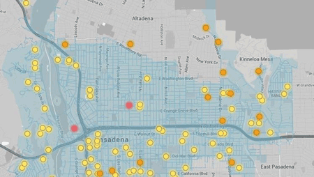
After analyzing the data in collaboration with scientists from Colorado State University, the researchers plotted the leaks and their relative size on an interactive map and reported the results to Southern California Gas Co., which serves millions of customers in Central and Southern California. (Link to article)

A screenshot of an interactive map by Environmental Defense Fund shows methane gas leaks from natural gas lines in Pasadena, California that were detected by a car equipped with an air monitor. Red points on the map represent high volume leaks; Orange points are medium; Yellow points are low. All the leaks were deemed non-hazardous. (Environmental Defense Fund)

